Austin Exploration Eagle Ford Well with Halcón Resources Has Good Initial Production (IP) Rates

Austin Exploration Eagle Ford Acreage Map

Australian-based Austin Exploration saw good initial production (IP) rates from its' first Eagle Ford well with farmee partner

Halcón Resources in late March 2014 of 1,066 boe/d (87% oil). The well (Stifflemire #1H) was drilled to a total depth of 17,000 feet with an 8000 foot horizontal leg into the Eagle Ford Shale.

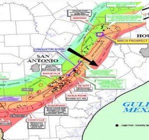
Austin Exploration entered the Eagle Ford in 2011, and in May 2013 announced a farm-out program with Halcón, whereby Halcón agreed to pay for the cost of three horizontal wells to earn a 70% interest in 4,400 acres of Austin's Birch Project. The cost to drill these wells is approximately $10 million per well.

The oil flow from our first Eagle Ford well with Halcón gives confidence for our highest expectations for the future potential of the wider field which has the capacity for another 100 drilling locations. It proves the value we saw in this property when we acquired it in 2011. It also confirms the decision to bring world class operator Halcón to the project to advance the drilling program. The success at Eagle Ford will generate the revenue needed to fund the further development of our projects.
— Austin Exploration Managing Director and CEO, Dr. Mark Hart

In April 2014, Austin announced that drilling had begun on the second and third wells in tandem due to the good initial production rates from the Stifflemire #1H). The Kaiser 2H and the Nemo 1H well be drilled to a planned total depth of 17,500 feet with an 8,000 to 10,000 foot lateral.

Austin has approximately 5,000 acres covering the Eagle Ford Shale formation in Burleson County, TX. The company is primarily targeting the Eagle Ford Shale and Austin Chalk, but is also prospective for the Taylor Sands, Buda Limestone and Georgetown formations.

Read more at austinexploration.com

U.S. Energy Corp. Provides Operations Update For Buda Limestone Wells

U.S. Energy Corp. Oil & Gas Project Area Map

This week, U.S Energy Corp. provided its operations update for several of it's Zavala and Dimmit County wells targeting the Buda Limestone formation, which lies just underneath the Eagle Ford Shale. The Beeler #6H well, located in the company's Booth-Tortuga acreage block, was completed in March 2014, and had a peak early 24-hour flow back rate of 1,185 boe/d, with a 91% oil yield. The company has a 30% working interest and a 22.5% net revenue interest in 12,457 acres of the Booth-Tortuga acreage block. Contango Oil & Gas Company is the operator.

U.S. Energy Corp. also participates with U.S. Enercorp in approximately 4,243 gross (636 net) acres in the Big Wells acreage block in Dimmit County, TX. The leasehold is contiguous to the southwestern portion of the Booth-Tortuga acreage block.

Having participated in six Buda wells with Contango and two with U.S. Enercorp., we are now beginning to gain a broader understanding of the extent of the play as well as the production response rates. Looking forward, we remain optimistic about the overall potential of the Booth-Tortuga and Big Wells prospects yet we still have much more drilling to do to fully understand the extent of the natural fractures in the region. Additionally, we believe that the potential exists to enhance the production profiles of our wells through down hole stimulation as warranted.
— U.S. Energy Corp. CEO, Keith Larsen

U.S. Energy Corp. Buda Limestone Well Spud Dates

  • Beeler #8H (Contango, Operator)

Spud on 2.06.14 - peak early 24-hour flow back rate of 886 boe/d; 30-day average production of 347 boe/d

  • Willerson #2H (U.S. Enercorp, Operator)

Spud on 2.03.14 - peak early 24-hour flow back rate of 634 boe/d

  • Beeler #6H (Contango, Operator)

Spud on 2.10.14 - peak early 24-hour flow back rate of 1,185 boe/d

  • Beeler #5H ST (Contango, Operator) & Beeler Unit A #9H (Contango, Operator)

Spud on 3.25.14 and 3.26.14 respectively. Currently these wells are being drilled to their target depths.

Read more at usnrg.com